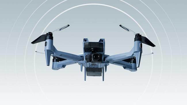
ACSL starts accepting orders for secure small aerial photography drone "SOTEN"
Feature 1. "Protect technology" with a secure domestic drone Security measures based on ISO15408*2 are implemented to prevent data leaks and extractions, and to achieve resistance to hijacking of the aircraft. I'm here. The main parts of the aircraft are made in Japan or procured from overseas with high reliability, and we are working to strengthen security by encrypting communication and shooting data and protecting acquired data in the domestic cloud. *2 International standard for computer security Feature 2: Camera that can be switched with one touchA wide range of camera options are provided by adopting a one-touch camera switching method, which is the first for a small aerial photography drone. is possible. In addition to the standard camera, the camera can be exchanged with an infrared camera + visible camera, a multispectral camera, and an optical zoom camera (under development). Feature 3. Aircraft with the flight performance required in the actual field With a maximum airspeed of 15 m / s, it is strong against wind and can be used safely even in severe environments such as disasters. In addition, it is equipped with SLAS/SBAS (quasi-zenith satellite system Michibiki's sub-meter-level positioning augmentation service), which can grasp more accurate position information in Japan, and grasps accurate position information such as surveys in the event of a disaster. It allows you to take off and land more safely when you need it. Feature 4. Broad scalability such as closed network LTE communication and offline maps Etc., you will be able to fly outside the visual line of sight (Level 3) without an assistant by automatic flight. By using the offline map, even in an environment where the Internet cannot be used, the offline map can be displayed on the base station application on the control side and the drone can fly automatically. We have also developed a mount for attaching a camera to the top of the fuselage, making it possible to shoot inspection images of infrastructure equipment from below.
[Product overview]
・Product name: SOTEN Price: Open price ・Dimensions: Arm extended: 637mm x 560mm (including propeller) Arm retracted: 162mm x 363mm ・Weight: 1.7kg (including standard camera and battery) ・Maximum flight time* 3: Standard battery: 22 minutes (with standard camera installed, under wind speed of 8m/s) Standard battery: 25 minutes (without standard camera, under wind speed of 8m/s) Large capacity battery: 25 minutes (with standard camera installed , under wind speed of 8m/s) Large-capacity battery: 29 minutes (when standard camera is not installed, under wind speed of 8m/s)・Maximum transmission distance (when there are no obstacles or radio wave interference): 4km・Dust/water resistance: IP43 (with camera, gimbal, and battery installed)・Standard camera: 4K video compatible 20 million pixels for still images・Optional cameras: Infrared camera + visible camera, multispectral camera, optical zoom camera (under development)・Remote ID*4: Bluetooth, GNSS *5: GPS + QZSS (Quasi-Zenith Satellite Michibiki) *6 + GLONASS *7 + SLAS/SBAS *8, Cloud: Captured image/video storage function, flight log storage function Security measures: Flight log/captured data leakage prevention , communication encryption, pairing between aircraft and transmitter ・Functions: automatic flight, image tracking, collision avoidance with 3-directional sensors ・Aircraft control protocol: MAVLink*9 compliant ・Accessories: standard transmitter, battery, standard charger , Secure Flight Management Cloud™*10 (3 years worth, 5GB) Optional items: smart controller, transmitter hood, spare propeller, training transmitter, propeller guard, LTE communication module, storage case (hardware), large capacity battery ( 94Wh), storage case (soft), multi-mount, triple charger, upper camera mount (under development) *3 Regarding flight time, it will change depending on the environment such as temperature and the number of times the battery is used. Please pay attention to the remaining battery power of the GCS app *4 A system that transmits identification information such as registration symbols and location information from drones in flight, and allows related parties to receive information *5 Global Navigation Satellite System Positioning navigation satellite system (satellite positioning system) *6 A navigation satellite system that can be used in Japan and the Asia-Pacific region *7 Satellite positioning system operated by the Russian Space Forces *8 Quasi-Zenith Satellite System Michibiki's sub-meter-level positioning augmentation service *9 Protocol related to transmission and reception of communication data between drones and ground stations *10 Provided by NTT Docomo, Inc., which can be centrally managed on the web, such as uploading images taken by drones and storing flight logs cloud service. "Secure Flight Management Cloud" is a trademark of NTT DOCOMO, INC. For purchase requests, consultations, and repairs, please contact the ACSL drone sales agent listed on the product site. URL: https://product.acsl.co.jp/flow/ Product information can be found on the small aerial drone (SOTEN) page on the product site. Product site Small aerial drone (SOTEN) https://product.acsl.co.jp/product/post-369/ [About ACSL Co., Ltd.] https://www.acsl.co.jp/ACSL is an industrial field In order to realize labor saving and unmanned operations in existing operations, we are developing domestic industrial drones. We offer industrial drones loaded with technology. It has already been adopted in various fields such as infrastructure inspection, mail/distribution, and disaster prevention.
Copyright © 2023 videocamera.website. All rights reserved.
